Manaslu Trek - 18 Days

Manaslu trek of 18 days trekking is popular trekking route in Manaslu region of Nepal. It offers the challenging but rich cultural experience with full of camping and tea-house accommodation option. Manaslu trekking in mid west Nepal takes you to the close of Manaslu Base Camp with Larke Pass crossing which is full of adventure.

Highlights of Manaslu Trek

  • It is one of the restricted trekking areas and the Nepal government applied a special rule.
  • Scenic drive to Arughat and Beshisahar to Kathmandu.
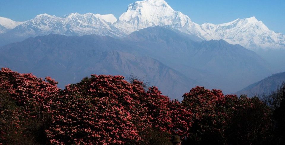
  • Attractive views of Himalchuli (7,893m), Manaslu (8163m), Annapurna range, Shringi(7,187m), Ganesh Himal, NgadiChuli (7,879m) and other mountains,
  • Visit remote part of Nepal and many verities of Culture and nature.
  • Pass over Larkya La Pass’ highest point and best viewpoint of this region.

Manaslu Trek – 18 Days is more or less regarded as a remote and pristine trek with remarkable views of Mount Manaslu; placed east of the Annapurna Himalayan range. The name Manaslu refers as “The Spirit of Mountain” According to the local language, it refers to be the substantial and strong divinity that dwells within. Manaslu Trek – 18 Days coarsely circles the world’s eighth highest mountain Manaslu (8,163 m); thus, becoming popular trekking trail for the travelers as other famous trekking trails like Everest, Annapurna, Langtang and so on. The Nepalese Government make the Trekking to Manaslu official in 1992, hence, has been open to organized trekking parties only.

Manaslu Larke (Larkye) La Pass (5,106 m) is a stimulating and steep pass and Manaslu Trek among the most chosen trekking destinations. Trekkers can hear some special dialects, as it is near the border of Nepal and Tibet. The remote trail of Manaslu Trek – 18 Days offer the perfect combination of rich cultural heritage and outstanding Himalayan beauty. Furthermore, the trail passes through the subtropical slopes of the Himalaya to the thirsty high Himalayan and to meadows bordering Tibet. Relatively few trekkers take this trek that is why; the environment is serene and still pristine with a true natural flavor. So if you love nature and also desire an easy and incredible trekking, this is definitely worth your time.

As Manaslu Trek is quite diverse to other regions, as it is anticipated that this trekking trail will be one of the most popular trekking trails very soon. According to the recent analysis of 2012, it has shown that the largest number of tourists made their trip to this region. This route of Manaslu Trekking – 18 Days is getting its fame for its array of scenery, cultural diversity, and it fledging lodges. Trekker with ample time can also include Tsum valley area with fewer trekkers, it has endured unabridged and unchanged for centuries.

Manaslu Trek is a moderate level trek and can be completed by all the avid trekkers throughout the world. This trek offers your lifetime unforgettable memories and makes your holiday awesome. Spring and autumn are the best seasons for Manaslu Circuit trekking/ Manaslu Trek. In these seasons, you can explore the pristine natural beauties and cultural heritages.

Outline Itinerary

DayProgramElevation
1Arrival and transfer to hotel in Kathmandu Upon arrival in Kathmandu.1440m
2Kathmandu1360m
3Kathmandu – Arughat  – Soti Khola : 135km, 8-9 hrs drive670m-710m
4Soti Khola – Machha Khola : ~14km, 6-7 hrs890m
5Machha Khola – Dobhan : ~11km, 6-7 hrs1000m
6Dobhan – Philim : ~10km, 6-7 hrs1590m
7Philim – Lokpa  – Chumling :~10km, 6-7 hrs2240m-2360m
8Deng – Namrung : ~12km, 6-7 hrs.2660m
9Namrung – Lho : ~4km, 3-4hrs3180m
10Lho – Sama Gaon : ~8km, 5-6 hrs3530m
11Sama – Samdo : ~8km, 3-4 hrs3860m
12Sama – Samdo : ~8km, 3-4 hrs3860m
13
Samdo – Larkya Phedi/Dharamsala : ~7km, 3-5 hrs
4460m
14Dharamsala – Larkya La  – Bimthang : ~12km, 7-9 hrs5160m-3720m
15Bimthang – Gho  ~12km, 5-6 hrs2515m-8250m
16Gho – Dharapani :~8km, 3-4 hrs1920m
17Dharapani- Besi Sahar (760m/2,495ft) – Kathmandu : ~ 190km 7-8hrs760m-1300m
18Final departure
Day 1
Arrival and transfer to hotel in Kathmandu Upon arrival in Kathmandu.

When you arrive in Kathmandu airport, our agency representative will be waiting for you in the airport holding our company and your name play card. From airport our agency representative will escort you to the hotel which takes 20 min of driving. After you check in to the hotel, you will rest and fed your flight sickness till next day. At hotel we will brief you about your schedule and plan of your trip.

Day 2
Kathmandu (1360m)

After breakfast, proceed for sightseeing tours to world heritage sites of Pashupatinath Temple-the holiest Hindu Temple on the bank of sacred Bagmati River, BodhanathStupa-the biggest Buddhist Stupa architecture in the world! Patan Durbar Square is the oldest city in the Kathmandu valley with age old tradition also called Lalitpur-the city of fine arts. The visit covers the Durbar Square, the Krishna temple, the Kumbheswore temple, the Golden temple and many more. SwayambhunathStupa-the 2000 years old legendary stupa on the hillock also nick-named as monkey temple.

Day 3
Kathmandu – Arughat (670m/2,198 ft) – Soti Khola (710m/2,330ft): 135km, 8-9 hrs drive

After having the night stay at the hotel in Kathmandu we heat the road with Early morning drive through Prithivi High to MalekhuPul and turn right hand side to DhadingBesi (district headquarter of Dhading); continues drive off road to Salentar and Aarughat Bazar. With the 5-6 hours drives we will have lunch and rest Aarughat. Aarughat is one of the famous shopping junctions for ManasluGorkha and Dhading’s remote villagers continue drive to Aarkhet Bazaar half an hours, if you are doing trekking in autumn or spring season there is possible direct bus to Aarkhet Bazar. After Aarkhet Bazar we need to change the local Jeep or bus for Sotikhola. It takes another 40 minutes or you can start trekking one hour to Sotikhola on same days, here we going to have the overnight stay

Day 4
Soti Khola – Machha Khola (890m/2,920ft): ~14km, 6-7 hrs

After breakfast at Sotikhola we will hike through plane area, following the Budi Gandaki river, small villages , the broad valley narrows and at times the trail is cut into the steep valley side, which is densely forested.. The terraced farmland here belongs to the village of LapuBesi. Treks descend once again to the wide, sandy riverbed and follow a path, which runs below the steep, craggy valley side. At length, we have to climb up once again on a trail to Machhekhaola 870m, Machhekhola means “Fish stream”, here we going to have the overnight stay at the tea house.

Day 5
Machha Khola – Dobhan (1,000m/3,280ft): ~11km, 6-7 hrs

The trail follows the river, with minor ups and downs, often dropping to the gravel bar before crossing the ThadoKhola and on up to Khorlabesi: where coffee, buckwheat and tobacco are grown. The GHT trail through Gorkha (and Barpak, epicentre of the first quake on 25/04/15) crosses our trail, heading east from Manaslu to the Langtang then Everest regions.

Enter a lush narrow gorge constricting the river’s progress. Cross a landslide with a dicey path, before the three hot spring spouts in Tatopani (930m). Climb a ridge then cross the BudhiGandaki (to avoid a cliff face and waterfalls). A good staircase, leads to a landslide before a final ridge climb to Dobhan.This where we going to have the night stay.

Day 6
Dobhan – Philim (1,590m/5,216ft): ~10km, 6-7 hrs

Exit over the DobhanKhola, then follow the east bank to the hamlet of ThuloDhunga (1 840m); above cataracts. Later the gradient lessens, the valley opens and the water is placid at Yaruphant (1 170m). Cross the YaruKhola (from Ganesh II and VI) on an old suspension bridge then climb to the teahouses at ThadoBharyang. Cross back to the west bank and ascend gently to the old paved village of Jagat (1 410m): entrance and checkpoint to the Manaslu Conservation Area.

Cross a tributary before a cliff-side trail to Salleri: with views of ShringiHimal (7 187m) to the north. Descend to Sirdibas; and the first symbols of Buddhist culture. A final bridge beyond GhattaKhola (1 480m, water mills) to the east bank, leads to a steep climb up to Philim: a prosperous Gurung village set amongst millet and maize fields; see the ChholingSanduGompa. Overnight in Philim.

Day 7
Philim – Lokpa (2,240m/7,350ft) – Chumling (2,360m/7,750ft):~10km, 6-7 hrs

From Philim we will trek through lush grasses and scrub up the exquisite narrowing valley to the village of Chisopani and then the millet fields of EkleBhatti (one house, 1 600m/5,250ft). The trail then gradually descends, beneath a spectacular waterfall, into the gorge below and a junction before “New Bridge” which leads to the Larkya La. (The right hand trail leads to the Tsum Valley). Cross the BudhiGandaki and enter its narrow gorge on an up-and-down trail with river crossings. After a suspension bridge the trail enters bamboo forest and rises to the village of Deng (1,800m/5,906ft). From here there are good views of ShringiHimal to the northeast. Here today we will have overnight at lodge in Deng.

Day 8
Deng – Namrung (2,660m/8,725ft): ~12km, 6-7 hrs.

Today the trail head through above the River then descend to cross the SerangKhola and later enters an impressive S bend between sheer basalt walls. To the right, huge rocky crags appear – with a spectacular waterfall above fields of maize and wheat. Beyond the valley broadens and turns northeast; the trail crosses a bridge before attractive village of Ghap (2,250m/7,382ft) on the south bank.The trail then ascends through bamboo, rhododendron and oak above the steeply descending river. For a short section it is forced back to the north bank by sheer walls and re-crosses back to the south bank on a wooden bridge (above a natural stone bridge) at a point where the river thunders down a narrow defile. Before reaching the village, the trail overlooks the Tum Khola from Tibet whose waters considerably increase the BudhiGandaki’s volume at the confluence. Then we will have overnight at lodge in Namrung.

Day 9
Namrung – Lho (3,180m/10,430ft): ~4km, 3-4hrs

FronNamrung whichis the entrance to Upper Nupri a region of purely Tibetan inhabitants . wecontinues trek through a mix of forest and extensive barley fields: guarded by bear watchers. In Lihi (2,900m/9,515ft), series of dwellings are grouped, each under a single shingled roof. There are impressive chortens, plus great views of HimalChuli (7,893m/25,897ft) to the south. Only the Ganesh Himal is visible to the east.

Then trail descend and enters a side-valley to cross the HinangKhola. Beyond the double-span bridge it rises sharply to a detailed chorten from where impressive views of NgadiChuli (7,873m/25,831ft) rise above the side-valley walls. Beyond are the packed houses of Sho (2,960m/9,712ft). Good views continue on the climb, past a large prayer wheel on the trail, up to Shrip. A steep pull leads to the ridge and the large village of Lho. Many of the stone houses in this region have distinctive wooden decks and shingles. The large Ribung monastery above the village houses ~150 monks. The best spot for sunset and sunrise pictures is from a Kani above the village; reached by a walk through barley fields, past a long mani wall and old chortens. Rise early for sunrise shots of Manaslu. Today we will have the overnight in lodge at Lho.

Day 10
Lho – Sama Gaon (3,530m/11,578ft): ~8km, 5-6 hrs

We will start our trek with a short climb to a plateau: and the badly deforested village of Shyala (3,520m/11,549ft). Huge mountains surround it: HimalChuli (7,893m/25,897ft) and Peak 29 (NgadiChuli, 7,873m/25,831ft) to the south; Manaslu (8,156m/26,760ft) and large glaciers ahead; more snow-capped peaks to the west and north.Further on, the trail crosses a bridge over the NumlaKhola that drains the Pungyen Glacier from Manaslu. Later a trail leads left to PungyenGompa. Continue down the broad valley, past a school, to a large chorten, beyond which a yellow kani leads to rows of houses with front courtyards that form the main part of Sama. The KargyuChholing Monastery stands above the far end of the village against a forested moraine. Only the upper sections of Manaslu and the Naike ridge are visible from the village. Today we will have overnight at lodge in Sama

Day 11
Sama: Rest and exploration day: Birendra Tal / Pungyen Gompa / Manaslu Base Camp

Sama is the regional center of Nupri. Explore the village architecture and customs. Cloth weaving for chubas and the manufacture of hooked rugs are important occupations for trade with Tibet. Yak and dzopkyo herds and horses are kept and traded.

The LabrangGompa in the lower village and the KargyuChholing Monastery on the rise beyond the village, were established some 500 years ago when this region was first settled by Tibetans. The monastery architecture is unique with fine woodwork. There are eight temple buildings: the largest, Pemba ChholingGompa, contains an impressive statue of Guru Rinpoche. It belongs to the Nyingma Buddhist sect and so most of its Lamas are married and live in dwellings at the complex.An easy and rewarding hike beyond the monastery is to the Birendra Tal (3,450m/11,319ft) below the Manaslu Glacier. It can be viewed from a hilltop or from a stony beach and offers striking views of the mountain. ~3km, 1½hrs

After exploring the Sama we will follow the trail towards Samdo to a bridge over the stream from the lake and then ascend the demanding trail that rises ~1 200m above the lake and the snout of the glacier to the Base Camp (~4,900m/16,100ft), ~8km, 5-6 hrs

Then a walk to the Pungyen Nunnery (3,870m/12,697ft) that stands on a plateau above the Pungyen Glacier offers unbeatable views of the Nadi ridges and Manaslu from near the gompa. It also adds an illuminating perspective of the mountain and its satellites to the other views seen along the circuit trail. From there we will walk back along the trail, past the school, to the turnoff to the Pungyen Nunnery. It lies over the ridge on a plateau above the glacier, and looks out onto Manaslu (known locally as Kang Pungyen). The ~2½hr trail through summer kharkas (no teahouses) along the NumaKhola and Pungyen Glacier can be icy and slippery. Above the complex is a cave gompa with yet better views. From there we will return back to lodge in Sama for the night stay.

Day 12
Sama – Samdo (3,860m/12,660ft): ~8km, 3-4 hrs

Today we will descend towards the BudhiGandaki, that has turned north, and pass the lake and Base Camp trail as well as several mani walls as the valley begins to widen. This is an easy trail along a shelf above the river past juniper and birch forests that surround KermoKharka. A stone wall divides the region into two with a stileand animal gate that separates the Sama and Samdo herds. Further on, the trail drops to cross the BudhiGandaki on a wooden bridge before climbing steeply onto a promontory above the confluence of the river with the MayolKhola from the Samdo Glacier to the northeast.

At the top is a stone arch, followed by fields before a white kani at the entrance to the village: an attractive, cold, yak and goat herding area. Zigzag up yak tracks behind the village to any of several sets of flags on a high ridge for superb 270o views: with Samdo Peak (6,335m/20,785ft) and its dramatic glacial basin to the east; the Sama Valley and its ranges to the south (Manaslu is masked by a rocky peak to the southwest); while to the west is a bird’s eye view over the northern Syacha Glacier from Manaslu (partially hidden) and tomorrow’s trail to Dharamsala and the Larkya La. Samdo is the last village before Gho, in the Manang District. Only informal kharkas (with lodges) lie between these villages. Today we will have overnight at lodge in Samdo.

Day 13
Samdo – Larkya Phedi/Dharamsala (4,460m/14,628ft): ~7km, 3-5 hrs

Today we will descend past the northern village fields to cross the BudhiGandaki for the last time at the remains of the Larkya Bazaar site. The river turns north up the PanaDanda Valley. Follow the westward trail on grassy slopes with scrub juniper, rhododendron and lichen covered granite above the SyachaKhola Valley. The source of the Syacha Glacier that descends from the Manaslu North ridge comes into sight. The trail works its way gradually up the valley towards the Larkya Glacier beyond the Larkya La Phedi, called Dharamsala. The guest house is a simple stone structure: with a kitchen and dining room, two separate buildings with 15 small double rooms, two tunnel-tents each with 8 cramped beds and a third for trekking staff. Short walks can lead to better views of the Larke (6,249m/20,503ft) and Naike (6,291m/20,641ft) peaks. Today we will spend overnight at Lodge in Dharamsala

Day 14
Dharamsala – Larkya La (5,160m/16,930ft) – Bimthang (3,720m/12,201ft): ~12km, 7-9 hrs

As today we are passing the pass needs, which can be very cold, especially if windy. Snow and ice conditions demand more care and time.Then the trail head to the northern moraine of the Larke Glacier, which is not steep or difficult but is long and continuously rocky underfoot. From Dharamsala, it rises gently to a ridge followed by a long gentle climb to the vast and jumbled moraine. Larke Peak on the LarkeHimal wall and Pawar Peak on the CheoHimal emerge to the south and north of the glacier. A short climb leads to an ablation valley followed by a drop to pass the first of four small scattered frozen lakes. A gradual ascent to the left up the glacial moraine and a final pull leads to the first set of summit flags. Back to the east; look over the trail to Tibetan border ranges beyond Samdo Peak. A long moraine-ridge runs from the first flags, parallel to the Larke wall and separated from it by a deep gully, to a second set of flags and astounding views ahead. To the west peaks include (anticlockwise from the north) the impressive Pawar Peak (6,620m/21,720ft), CheoHimal (6,820m/22,376ft), the Himlung pyramid (7,126m/23,380ft), Gyaji Kung (7,030m23,065ft), Kang Garu (6,981m/22,905ft) plus Annapurna II (7,937m/26,041ft) and its satellites away to the east. Below lies a magnificent basin within dramatic rock and ice walls from which flow a complex of glaciers.

The descent begins from these flags and drops steeply off the moraine then traverses loose scree slopes down a set of steep zigzags to the grassy DangbocheKharka (4,450m/14,600ft) almost directly below.The trail offers a beautiful view of the glacial action that feeds the upper Dudh (milk) Khola. From the PawarHimal, the Salpudanda Glacier merges with the Ponkar Glacier below the medial Ponkar Lake (trapped between their moraines) and is then joined by the western Kechakyu Glacier to form the Bimthang Glacier that exists the valley.

From DangbocheKharka the gradient eases and the trail follows the curve of the lateral moraine of the Salpudanda/Bimthang glacier into the lovely Bimthang Valley. Bimthang is now the summer grazing settlement for the people of Samdo. Before the closure of the Tibetan border it was an important trading post. The Tibetan Khampa warriors held a centre here in the 1970s.then we will spend overnight at lodge in Bimthang.

Day 15
Bimthang – Gho (2,515m/8,250ft), ~12km, 5-6 hrs

Today we will start our trek with a walk across theBimthang Plain, and descend through the stony glacier then up and over the far moraine to enter magnificent pristine rhododendron and pine forest. Views back towards the Larke, Manaslu, Nadi and ChuliHimals are excellent all along this route. The trail descends along the west bank of the Dudh (milk) Khola past Hompuk (3,430m/11,254ft, a rock shelter near the bridge) and attractive SanguraKharka (3,020m/9,909ft) before descending steeply to the highest cultivated land at Karche (2,700m/8,860ft). Beyond is a flood related landslide, more terraced fields and a steep ridge climb before dropping to the substantial (Gurung) village of Gho. Today we will spend overnight at lodge in warmer Gho

Day 16
Gho – Dharapani (1,920m/6,300ft)):~8km, 3-4 hrs

After breakfast we will trek through farmlands to the old paved village of Tilje (2,300m/7,546ft), then cross to the east bank of the river before descending rapidly towards the Marsyangdi Valley through scrub forest. Cross back to the west bank just before Thonje (1,965m/6,447ft) and then, in Thonje, cross the MarsyangdiKhola (from Manang) just above the confluence before joining the new road along the main Annapurna Circuit route in Dharpani at the perfect lunch time and end of the trek. Afternoon enjoy hot shower and wonder around this Tibetan village. Today we spend overnight at Lodge in Dharapani

Day 17
Dharapani- Besi Sahar (760m/2,495ft) – Kathmandu (1,300m/4,264ft): ~ 190km 7-8hrs

After breakfast, we will toward the Besisahar with jeep ride along the dusty and bumpy off road and then through the paved road we go back to Kathmandu

Day 18
Final departure

After breakfast, transfer to Tribhuvan International Airport for your onward flight to your next destination.

Price Includes

  • Airport Pick and Drop by private Transport
  • Hotel in Kathmandu with B/B basic (One Night) (Centrally located, attach bathroom, hot and cold shower)
  • TIMS CARD (Trekking Information Management System). We need two photograph each for permit.
  • Manaslu Conservation Area Fee
  • Annapurna Conservation Fee
  • Manaslu Special Permit
  • 16 days porter wages and his insurances/meals/accommodation/equipments
  • 16 days guide wages and his insurances/meals/accommodation/equpipments
  • 16 nights best Lodge accommodation during the trek on tea house services.
  • Kathmandu to Arughat by Local Bus
  • Dharapani to Besisahar by Jeep Sharing
  • Besisahar to Kathmandu by Local Bus
  • Rescue arrangement in emergency situation & worst weather condition
  • Trekking poles, sleeping bag, down jacket/duffle bag (we provide these if necessary).
  • Trekking maps.
  • Rubbish disposal.
  • Our service charge and government taxes.

Cost Excludes

  • All meals in Kathmandu and during trekking
  • Extra nights hotel stay in Kathmandu.
  • Tips to guides and support staff.
  • Additional costs in case of emergency (You must have adequate travel insurance to cover any kind of emergencies, such as ground transportation & Heli recue/medical/hospitalization. Medical etc).
  • Your International flight ticket airfare
  • Energetic chocolate/energy drinks/alcohol/mineral water/cigarettes/packing food snacks etc
  • Additional medication for altitude sickness (Acetazolamide etc).
  • Personal expenses and any other unforeseen expenses, such as Laundry/WIFI on trek/phone call
  • Personal trekking equipment.
  • Nepal entry visa fees which can get up on your arrival in Kathmandu airport
  • Sightseeing tour and All the entrance fees of temple in Kathmandu
  • Services not mentioned herein
1. How difficult are the treks?

It depends on the individuals’ adaptation of walking in any situation and at any circumstances. It depends on the location and choice of trekkers. Both difficult as well as easy treks are available. Difficulty of the treks depends on the region of the trek and duration of it. Shorter treks tend to be easier while longer ones require some physical fitness.

2. How safe Women traveling alone with your company?

Completely, we assure the safety and security of the women travelling with us. We will provide the privacy that the women need. We will also give you a personal room on lodge and personal tent for camping while trekking.

3. What is tea house trekking?

Tea House Trek – is a trek during which at the end of each trekking day you stay for overnight in Tea Houses. “Trekking Guide Team Adventure” also organizes Camping Treks during which you stay for overnight in tents which our guides will set up for you and food during such treks will be cooked by our experienced cook.

4. Can I get Nepal visa on arrival?

Yes, you can get it in Tribhuvan International Airport in Kathmandu. As you arrive to airport fill the form and proceed to the visa line. You have to pay 25US$ for 15 days of visa from the day of issue, 40US$ for 30days and 100US$ for 90 days of tourist visa. For this you have to bring two passport size photos.

5. What is the best air route to my destination?

There are enough airline companies operating daily flights from Middle East of Kathmandu. Kathmandu only has got only international airport in Nepal so, where ever you are coming from you must come through tribhuvan international airport.

6. What type of insurance should I have before come to Nepal? Can I get it there?

For coming to Nepal you should have both medical and Rescue evacuation insurance. Yes you can get it here too, but we recommend purchasing it in your own country to avoid any last minute hassle and basal.

7. When should I travel to Nepal?

In Nepal it rains a lot between Junes to August. You too can enjoy great treks during this period of year in rain shadow region. But if you planning for more popular trek autumn and spring is the best time. As during this period climate will be moderate and will favorable for the trekking.

8. What kinds of banking facilities in Nepal?

Nepal has modern banking facilities having branches of some international bank. Almost all foreign currency along with credit card such as American Express, Visa and Master card are accepted. Nepal also has ATM facilities.

9. When should I book my trip?

We suggest you to book your trip in advance to avoid the disappointment and hassles. We too will make an effort to accommodate last minute bookings but some time due to the last minute planning we may unintentionally make few mistake which may offend you so it will be better to do advance booking.

10. Is someone going to meet me at the airport? Are transfers included?

Yes, our agency representative will pick you from airport. We will be displaying our placard of your name with our agency name.

11. How much spending money should I bring?

This depends on the destination you will be at and package, facilities you may choose . However our trip profile will give you information about how to budget form additional meals, optional excursions and extra expenses that might occur in any specific trip.

12. Does your company help to arrange domestic flight, international flight, hotel bookings and other services?

Since we are Nepal based company we refer to arrange your international flights from your home town. But domestic flight ticket will be included in our package. Other help like river rafting, city guided tour, mountain flight, jungle safari will be provided according to your necessities.

13. What is the physical conditioning level needed for trekking?

If you are in good physical condition then you do not require any hiking experience for short trekking. But if you are planning for the longer ones then you should do long day hikes at your home.

14. Is a Trekking permit needed?

Permit is not required for trekking in Everest, Annapurna, Langtang and some other regions. However, conservation permits or National park permits are required. There are few restricted trekking areas in Nepal where trekking permits are required.

15. Are the food / water safe to eat / drink?

All the meals are prepared with high standards of hygiene, fruit and vegetables are soaked in iodine before preparation. Most of lodges serve boiled and filter water which is safe. It is also possible to buy the bottle of mineral water in the trek.

16. What happens if there is an emergency?

All of our guides are trained with first aid and have basic idea about the physical problems that may arise during trekking. If an emergency occur then we will cover initial expenses of rescue operation as these expenses will need to be recovered from your insurance company. For minor cases there are health posts established by foreign doctors and many are staffed by overseas personnel.

17. What are your payment terms?

You need to pay 30% of total price as advance deposit to conform reservation before arriving to Nepal. Rest of the payment can be paid after arrival.

18. Can we bring some food from home?

You can bring power bars, cereal bars and similar high energy foods, powder Gatorade is also recommended to fight dehydration.

20. Is there any communication when we are on the mountain?

In the way in many villages along the popular trekking routes you can find telephones from where you can make international calls. And now a days we have the internet facilities most of the trekking destination.

21. What’s the difference between trekking, hiking and mountain climbing?

You can do all day walk, where you stay overnight (or several nights) at three activities in Nepal, but they are quite different things. Trekking is a multi-the place you’ve walked to.
Hiking generally refers to a one-day walk. It might be two hours or eight, but if it takes place within a single day, it’ll probably be referred to as a hike.
Mountain climbing is another thing entirely. It takes special equipment, training and comes with more risk. Neither trekking nor hiking require any special skill, other than the ability to walk.

Permit & Entry Fees:

It is compulsory to pay Everest National Park entry fee and TIMS card to trek in this area.

Medical Support:

An emergency first aid kit is carried by the support staff at all times.

Accommodation and meals:

During tea house treks our guests pay for their food (breakfast/lunch/dinner) at the lodge while we provide guides/accommodation/necessary permit and transportation. It can be USD $25 per person each day for food (Lunch/dinner/breakfast)

Water:

Mineral waters are available at all stops during tea house treks. You can also use tap water if you choose to use water purification tablets.

Travel Insurance:

Travel Insurance is mandatory for all clients who choose to trek or climb with us. The insurance should cover you in case of emergencies like accidents, altitude sickness and ambulance and helicopter rescue charges if required. Please carry a copy of your insurance papers while travelling in Nepal and do send us a copy as well. This will help us in making all the necessary arrangements in case of any sort of emergencies.

Best Season for Everest Panorama View Trek

  • Spring : March – May
  • Summer: June – August
  • Autumn: September – November
  • Winter: December – February

While there are no seasonal constraints on traveling to Nepal, different regions are best visited in different seasons. Once you inquire about any trekking itinerary we’ll email you regarding the best season for that particular trek.

Check-list of personal equipment:

  • Good standard trekking boots
  • Camping shoes/thongs
  • Socks-polypropylene
  • Down Jacket
  • Fleece
  • T-shirts
  • Trekking trousers
  • Shorts (both casual and for treks)
  • Swim wear
  • Sun Hat
  • Woollen Hat
  • Nylon Windbreaker
  • Gloves
  • Gaters
  • Strong Rucksack
  • Sleeping Bag
  • Water Bottle
  • Torch/headlamp (with spare batteries)
  • Toiletries/soap
  • Toilet paper
  • Sun block
  • Travel Towel
  • Wet-wipes
  • Medication (cough medicine, throat soothers, water purification tablets)
  • Sunglasses
  • Binoculars
  • Camera & lenses
  • Memory cards
  • GPS Tracking Units may be helpful
  • Altimeter
  • Compass
  • Book/music player/pack of cards
  • Padlock
  • A plastic bag for waste
  • Energy/snack bars

Write a Review

Your email address will not be published.

Your review will appear after admin approves it.

Please fill all the fields.

You can send your enquiry via the form below.

Manaslu Trek